This has been a common route for me over the decades. When I first moved here, the freeways were just being built. Okay by me, I liked the backroads. The industrial/railroad frontage wasn't the most attractive route but I soon worked out a way in along the river.
When I cross this bridge these days, I often get stuck in backed up traffic right on top of this arched bridge. I find that disconcerting. There is now a traffic light just there at the far edge of the little farm field. The farm field is fairly nicely landscaped these days. An office building for the local power company sits back a ways from the street. It is indeed still divided lanes with the boulevard of trees and continues for about 20 blocks to what was then known as "Victoria Street." I guess the powers that were decided that this sounded too British Columbian so it was changed to the romantic, "Division Street."
Speaking of division, I'll have to see if the Museum of North Idaho has any online archives. There is precious little that the state organization considers of interest, north of Boise.
If you click the picture you can read the "Miners and Travelers' Guide to Oregon, Washington, Idaho, Montana, . . ." by John Mullan. Captain Mullan was responsible for building the road for the US Army between 1859 & 1862. You will learn where you might find fresh grass for your draft animals between Fort Walla Walla Washington and Fort Benton Montana .
That's a great link! It's so interesting to read about familiar landmarks that were observed so many years ago when it was just raw country. I started reading the chapter on snow and weather...have to get back to that later.
Mullan suffered a great deal in his efforts. Trying to find a pass over the mountains began before he started constructing the "road." He was on the Montana side a year or 2 before the $ was authorized. Then, when he worked his way back to build the road from the west, Montana wasn't any easier for him and the guys with him. I believe that was when one of them lost his legs to frostbite. Not just a toe or 2 . . !
Now let see how things went on his building the road from Walla Walla: They progressed at breakneck speed! What was it - something like 600+ miles of "road building" in 2 years? He had something like 100 men at first and a lot of these guys were along for protection from the Indians. Yeah, the INDIAN trails were already there. They'd been herding 1,000's of horses along those trails.
Then Mullan gets into the mountains of Idaho and has this MAJOR problem with trees, trees, and more trees! Fallen trees, big trees, little trees! He complains to the Indians on the Coeur d'Alene River, when he finally reaches them, "Why the heck haven't you cleared some of those dang trees?!" Or, words to that effect.
Didn't it occur to him that they didn't want anyone coming up from the lake thatta way? He realized latter, and said as much if'n I remember correctly, that he should have gone by way of the Clark's Fork River. But, more than that, the Coeur d'Alene got around just fine in their world - in canoes! They didn't want half the people in this part of the world herding horses, etc. thru their river valley.
Horses to Montana, they could run them up the valley here to the Clark's Fork - where they'd been driving horses over the mountains so that the Blackfoot, etc. could buy them and hunt their buffalo. It was a "planned obsolesce" deal. They'd take a horse over this year, the Montana Indians would hunt off of him thru the season. Winter would come and the horse would die in the severe weather. Meanwhile, the Indians here would have all these lovely young horses on the Palouse. They'd take those over the next year and sell them. It was a BIG deal!
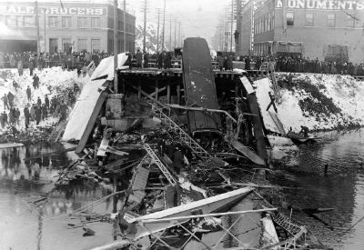
Yow, is that a collapsed bridge?
I've always felt that if you're going to drive on a bridge that's going to collapse you should at least plan to do it in the summer.
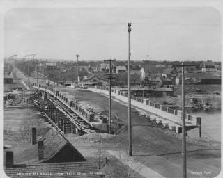
It is interesting that in the state archives that picture is reversed, Thistle'
I've turned it around on Photobucket after I realized that; the gnomes in charge there will straighten it out directly.
Yes, it is looking north from downtown Spokane. That big rock outcropping is still there and has that hotel up there - can't think of the name. I am wondering if the building in front of it is still there . . . Pier One, I think.
Yes, 5 people died. It seems that I remember that 20+ people died building the railroad overpass just up Division when dynamite exploded prematurely, blasting the rock out of the way. It was some where back in those days. The camera is facing away from that location.

") .
.