Sandy, Predicted

digitS'

Garden Master
Joined
Dec 13, 2007
Messages
25,898
Reaction score
29,343
Points
457
Location
border, ID/WA(!)
In the most populated part of the US . .

. You folks know about this, right?

Sandy.gif


A very quick turn and move off to the NW for Sandy's predicted path.

Steve
 

Ridgerunner

Garden Master
Joined
Mar 20, 2009
Messages
8,227
Reaction score
10,050
Points
397
Location
Southeast Louisiana Zone 9A
Yeah, I've been looking at computer models for the predicted path. It's pretty sure somebody is going to get hit, just not sure exactly where and when it goes ashore. Categorywise it does not sound that bad, but don't be lulled by that. I think it was Allison that didn't even make hurricane status and still caused a lot of damage. But there have been some pretty intense storms that did not do that much damage. There is just so much variation with these things.

But it is clearly a dagger pointed at a lot of people. They need to start getting ready. I hope it turns out to be a fast-moving storm that does not just set there and pound and build up the storm surge. Isaac wasn't really that strong but did a lot of damage because it was so slow.

I'n concerned about this one even though I don't have anyone close in the path. I really hope and pray it is pretty much a non-event for most people.
 

digitS'

Garden Master
Joined
Dec 13, 2007
Messages
25,898
Reaction score
29,343
Points
457
Location
border, ID/WA(!)
Here are the 50 knot (58mph) winds predicted.

Time is 8am today thru 8am Wednesday.

Sandyswind.jpg


I've never wanted to live in a high rise. I have trouble imagining what it would be like to lose the electricity if your apartment is many floors above the ground . . . I've got the option of being outdoors cooking with propane, charcoal, wood . . . the river isn't all that far away :rolleyes:. That is, if an east coast hurricane sets off a west coast earthquake, which causes Mount St. Helens to blow up again . . .

Steve
 

baymule

Garden Master
Joined
Mar 20, 2011
Messages
18,448
Reaction score
35,189
Points
457
Location
Trinity County Texas
I sure feel for those folks in the path of this storm. I live in hurricane alley. It means floods, winds, damage, no power, stores closed, no water and a bunch of unhappy people. We always do OK here, because I make sure we are well stocked on things. In hurricane Ike, a huge oak fell on the house and crushed one end. I was real glad to have brownies (baked before the storm hit) and a box of cheap wine. (not really a drinker, so a little bit sends me to the moon lol) So, that night, with rain falling in the house, I ate my brownies, drank my wine, and I really didn't care about the rain. :lol:
 

digitS'

Garden Master
Joined
Dec 13, 2007
Messages
25,898
Reaction score
29,343
Points
457
Location
border, ID/WA(!)
I am a little encouraged by this one. It is from a meteorologist at Florida State U but is something he refers to as "experimental." Yesterday, he was saying quite remarkable things! It was not very reassuring then!

Sandygif2.gif


As I say, this seems to be 1 Florida meteorologist's idea this afternoon and I'm sure that he is perfectly willing to change his mind by tomorrow morning. You can see the winds fall away as the storm comes in. It looks to me that this model shows the eye of the hurricane, or center of the tropical storm if it stays at that level, coming into Virginia. That's further south than the earlier models, I believe.

Keep in mind, I know very, very little about even how to interpret these models . . . Okay?

Steve
 

digitS'

Garden Master
Joined
Dec 13, 2007
Messages
25,898
Reaction score
29,343
Points
457
Location
border, ID/WA(!)
This is not anything about prediction - folks in areas affected must already be getting all kinds of that by now.

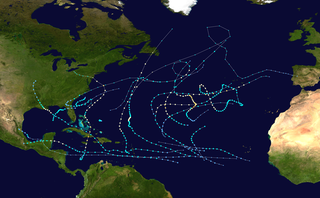
This is about the season and the Weather Service won't be updating its information for a few more days, as we get into November. I thought the map/photo I found on Wikipedia was interesting, tho'.

The Weather Service said that this season has been: "In terms of accumulated cyclone energy...which measures the combined strength and duration of tropical storms and hurricanes...tropical cyclone activity so far this year is about 50 percent above the 1981-2010 average through the end of September in the Atlantic Basin." (link) (And, I've spared you all of the capital letters ;).)

I don't really know much about hurricanes but it seems that the storms this year have not been terribly powerful. If I read the info right, there have been no category 4 or 5 storms but if you add up the smaller storms, it has been quite a year (even by the 1st of October)!

This map on Wikipedia seems to have been updated 3 days ago. It show the tracks of the 2012 storms and most have stayed well away from land.

320px-2012_Atlantic_hurricane_season_summary_map.png


Steve
 

catjac1975

Garden Master
Joined
Jul 22, 2010
Messages
8,962
Reaction score
8,940
Points
397
Location
Mattapoisett, Massachusetts
Our governor has already declared a state of emergency. The wind has started and the rain will come soon. The water at the fish ladder has been released on our river. As long as the water doesn't raise too high we may be OK. If the power goes out and the water raises our cellar will flood. That hasn't happened in a long time. Oh, yea, not since the last"Perfect Storm."
 

journey11

Garden Master
Joined
Sep 1, 2009
Messages
8,470
Reaction score
4,222
Points
397
Location
WV, Zone 6B
My thoughts and prayers are with you Catjac, and everyone else in the thick of it. We are on the perimeter of the warning area, but from what I hear the flooding will be the worst of it. A lot of folks affected by this one will overlap with those who had the week long+ power outage in July.
 

digitS'

Garden Master
Joined
Dec 13, 2007
Messages
25,898
Reaction score
29,343
Points
457
Location
border, ID/WA(!)
http://google.org/crisismap/2012-sandy

I came across this and it looks like a useful way of exploring what is predicted and what is happening with the storm.

-- If you go to the page, unclick ALL of the boxes on the right. --

Then, you can decide how YOU want to fill the map! It started off showing shelters, etc. etc. etc. If you need information on those sorts of things = better do some zooming to show areas very close to ground level. Otherwise, it is difficult to see the forest for the trees.

And, I hope all the trees are left standing after Sandy :/.

Steve

BTW - I have seen a prediction map where the storm goes in a much more northerly direction once it gets inland. Google shows the weather.com prediction of a northeasterly track. In other words, there are models that suggest Sandy goes straight across Lake Ontario into Canada.
 

digitS'

Garden Master
Joined
Dec 13, 2007
Messages
25,898
Reaction score
29,343
Points
457
Location
border, ID/WA(!)
Serious flooding in Atlantic City and all along the NJ coast. This came with the morning's high tide.

Afternoon high tide pending.

The hurricane center is still 200 miles to the South East.

Have I missed something? I don't see people filling sandbags on teevee in a kind of property-by-property way. And no, I'm not concerned about casinos but are individuals just kind of rolling the dice? More military called out for this than were on-hand for Katrina but that's a national effort.

Steve
 
Top